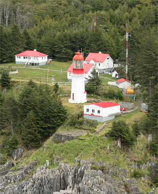
About: Langara Light Goto Sponge NotDistinct Permalink
An Entity of Type : umbel-rc:Lighhouse,
within Data Space : dbpedia.demo.openlinksw.com associated with source document(s)

![http://dbpedia.demo.openlinksw.com/describe/?url=http%3A%2F%2Fdbpedia.org%2Fresource%2FLangara_Light&invfp=IFP_OFF&sas=SAME_AS_OFF&graph=http%3A%2F%2Fdbpedia.org&graph=http%3A%2F%2Fdbpedia.org]()

The Langara Point Lighthouse is a manned lighthouse located atop a scenic bluff on the northwest corner of Langara Island. It is one of only two lighthouses in Haida Gwaii – the other being at Cape St. James (now an automated station), at the southern tip of the islands. Both were built in 1913. During World War II, the lighthouse was painted camouflage green and a radar station was built here to monitor the North Pacific.
| Attributes | Values |
|---|---|
| rdf:type |
|
| rdfs:label |
|
| rdfs:comment |
|
| foaf:name |
|
| name |
|
| geo:lat |
|
| geo:long |
|
| location | |
| dcterms:subject | |
| Wikipage page ID |
|
| Wikipage revision ID |
|
| Link from a Wikipage to another Wikipage |
|
| Link from a Wikipage to an external page | |
| sameAs | |
| yearbuilt |
|
| dbp:wikiPageUsesTemplate | |
| construction |
|
| location | |
| shape |
|
| georss:point |
|
| has abstract |
|
| characteristic |
|
| managingagent |
|
| marking |
|
| gold:hypernym | |
| prov:wasDerivedFrom | |
| page length (characters) of wiki page |
|
| building end date |
|
| height (μ) |
|
| foaf:isPrimaryTopicOf | |
| geo:geometry |
|
| is name of | |
| is Link from a Wikipage to another Wikipage of |
Faceted Search & Find service v1.17_git139 as of Feb 29 2024


![[RDF Data]](/fct/images/sw-rdf-blue.png)

OpenLink Virtuoso version 08.03.3330 as of Mar 19 2024, on Linux (x86_64-generic-linux-glibc212), Single-Server Edition (378 GB total memory, 67 GB memory in use)
Data on this page belongs to its respective rights holders.
Virtuoso Faceted Browser Copyright © 2009-2024 OpenLink Software


![[RDF Data]](/fct/images/sw-rdf-blue.png)
OpenLink Virtuoso version 08.03.3330 as of Mar 19 2024, on Linux (x86_64-generic-linux-glibc212), Single-Server Edition (378 GB total memory, 67 GB memory in use)
Data on this page belongs to its respective rights holders.
Virtuoso Faceted Browser Copyright © 2009-2024 OpenLink Software


![[cxml]](/fct/images/cxml_doc.png)
![[csv]](/fct/images/csv_doc.png)
![[text]](/fct/images/ntriples_doc.png)
![[turtle]](/fct/images/n3turtle_doc.png)
![[ld+json]](/fct/images/jsonld_doc.png)
![[rdf+json]](/fct/images/json_doc.png)
![[rdf+xml]](/fct/images/xml_doc.png)
![[atom+xml]](/fct/images/atom_doc.png)
![[html]](/fct/images/html_doc.png)