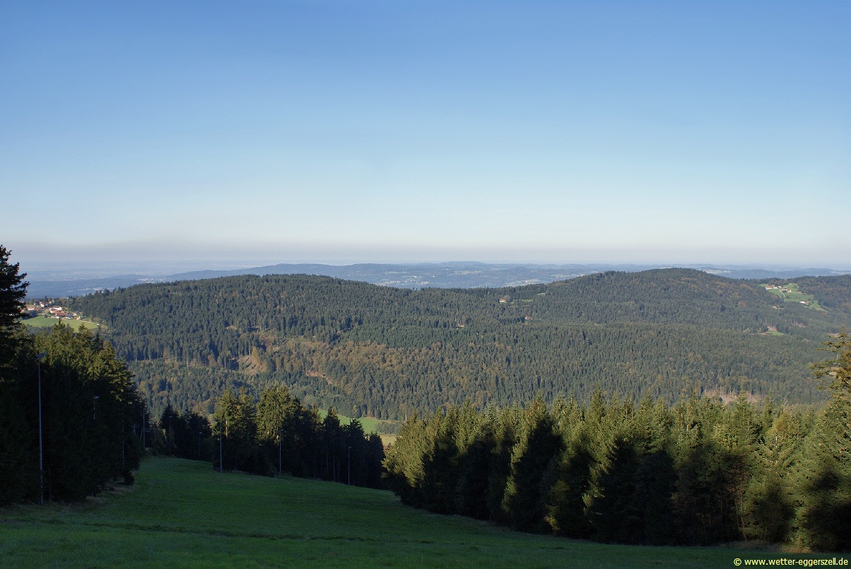
The Hadriwa [Hádriwɐ] is a completely forested mountain, 922 m, near Elisabethszell in the municipality of Haibach in the Bavarian Forest in Germany. It is the highest point on the ridge between the Klinglbach and Grüner Bach in the east and the and the Menach and its side streams in the west. According to a survey, the Hadriwa is one of 16 possible top sites for pumped-storage hydroelectric stations in Bavaria. In Straubing-Bogen county, the to the south and the Kobelberg near Wiesenfelden are also among the sites deemed suitable for such installations.
| Attributes | Values |
|---|
| rdf:type
| |
| rdfs:label
| - Hadriwa (Vorderer Bayerischer Wald) (de)
- Hadriwa (Bavarian Forest, Haibach) (en)
|
| rdfs:comment
| - The Hadriwa [Hádriwɐ] is a completely forested mountain, 922 m, near Elisabethszell in the municipality of Haibach in the Bavarian Forest in Germany. It is the highest point on the ridge between the Klinglbach and Grüner Bach in the east and the and the Menach and its side streams in the west. According to a survey, the Hadriwa is one of 16 possible top sites for pumped-storage hydroelectric stations in Bavaria. In Straubing-Bogen county, the to the south and the Kobelberg near Wiesenfelden are also among the sites deemed suitable for such installations. (en)
- Mit 922 m Höhe ist der Hadriwa [Hádriwɐ] ein vollständig bewaldeter Berg bei Elisabethszell, Gemeinde Haibach im Bayerischen Wald. Er ist die höchste Erhebung des Höhenzugs zwischen dem und im Osten und Elisabethszeller Bach und der Menach mit ihren Seitenbächen im Westen. Der Hadriwa ist laut einer Potentialanalyse einer von 16 möglichen Top-Standorten für Pumpspeicherwerke in Bayern. Im Landkreis Straubing-Bogen werden auch der unmittelbar südlich gelegene Pfarrerberg und der Kobelberg bei Wiesenfelden zu diesen in besonderer Weise geeigneten Standorten für Pumpspeicherwerke gerechnet. (de)
|
| foaf:name
| |
| name
| |
| geo:lat
| |
| geo:long
| |
| foaf:depiction
| |
| dct:subject
| |
| Wikipage page ID
| |
| Wikipage revision ID
| |
| Link from a Wikipage to another Wikipage
| |
| Link from a Wikipage to an external page
| |
| sameAs
| |
| dbp:wikiPageUsesTemplate
| |
| thumbnail
| |
| isolation
| |
| photo size
| |
| location
| |
| photo
| - Blick vom Hadriwa-Kamm in die Donauebene .JPG (en)
|
| photo caption
| - View of the Danube Plain from the crest of the Hadriwa (en)
|
| prominence
| |
| range
| |
| georss:point
| - 49.03476111111111 12.766366666666666
|
| has abstract
| - Mit 922 m Höhe ist der Hadriwa [Hádriwɐ] ein vollständig bewaldeter Berg bei Elisabethszell, Gemeinde Haibach im Bayerischen Wald. Er ist die höchste Erhebung des Höhenzugs zwischen dem und im Osten und Elisabethszeller Bach und der Menach mit ihren Seitenbächen im Westen. Der Hadriwa ist laut einer Potentialanalyse einer von 16 möglichen Top-Standorten für Pumpspeicherwerke in Bayern. Im Landkreis Straubing-Bogen werden auch der unmittelbar südlich gelegene Pfarrerberg und der Kobelberg bei Wiesenfelden zu diesen in besonderer Weise geeigneten Standorten für Pumpspeicherwerke gerechnet. Bis etwa zum Beginn des 20. Jahrhunderts bestand nahe dem Gipfel die Einöde Hadriwa, deren Spuren heute noch durch Reste eines Gebäudes und gut erhaltene Lesesteinmauern sichtbar sind. Die Herkunft des Namens ist ungeklärt. Eine der Namensdeutungen basiert auf dem tschechischen Wort "Hadr", für Uneinigkeit, Streit, Zank und der Tatsache einer früheren Gebietsgrenze der Klöster Oberalteich und Windberg in diesem Bereich. Auch eine weitere Deutung bezieht sich auf ein tschechisches Wort, auf "Had" für Schlange. Es gibt noch einen weiteren Berg Hadriwa (677 m) im Bayerischen Wald in der Gemeinde Zell, Landkreis Cham. (de)
- The Hadriwa [Hádriwɐ] is a completely forested mountain, 922 m, near Elisabethszell in the municipality of Haibach in the Bavarian Forest in Germany. It is the highest point on the ridge between the Klinglbach and Grüner Bach in the east and the and the Menach and its side streams in the west. According to a survey, the Hadriwa is one of 16 possible top sites for pumped-storage hydroelectric stations in Bavaria. In Straubing-Bogen county, the to the south and the Kobelberg near Wiesenfelden are also among the sites deemed suitable for such installations. Until the early 20th century, there was a farmstead near the summit, also called the . Today its traces are still visible in the form of the remains of a building and well-preserved rubble stone walls. The origin of the name is unclear. One possible meaning is based on the Czech word, Hadr, for disagreement, quarrel, strife and the fact that the boundary between the abbeys of Oberalteich and Windberg passed through this area. Another possibility is that it relates to a Czech word, Had, for snake. There is another mountain called the Hadriwa (677 m) in the Bavarian Forest in the municipality of Zell in the county of Cham. (en)
|
| prov:wasDerivedFrom
| |
| page length (characters) of wiki page
| |
| located in area
| |
| mountain range
| |
| foaf:isPrimaryTopicOf
| |
| geo:geometry
| - POINT(12.766366958618 49.034759521484)
|
| is Link from a Wikipage to another Wikipage
of | |
| is Wikipage disambiguates
of | |
| is foaf:primaryTopic
of | |

![http://dbpedia.demo.openlinksw.com/c/2UiBug6eWt]()


![[RDF Data]](/fct/images/sw-rdf-blue.png)


![[RDF Data]](/fct/images/sw-rdf-blue.png)

.jpg)

![[cxml]](/fct/images/cxml_doc.png)
![[csv]](/fct/images/csv_doc.png)
![[text]](/fct/images/ntriples_doc.png)
![[turtle]](/fct/images/n3turtle_doc.png)
![[ld+json]](/fct/images/jsonld_doc.png)
![[rdf+json]](/fct/images/json_doc.png)
![[rdf+xml]](/fct/images/xml_doc.png)
![[atom+xml]](/fct/images/atom_doc.png)
![[html]](/fct/images/html_doc.png)