About: Babai River     Goto   Sponge   NotDistinct   Permalink

An Entity of Type : yago:WikicatRiversOfUttarPradesh, within Data Space : dbpedia.demo.openlinksw.com associated with source document(s)
QRcode icon
http://dbpedia.demo.openlinksw.com/describe/?url=http%3A%2F%2Fdbpedia.org%2Fresource%2FBabai_River&invfp=IFP_OFF&sas=SAME_AS_OFF

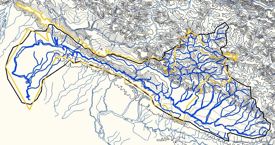
The Babai River (Nepali: बबई नदी) originates in and completely drains Inner Terai Dang Valley of Mid-Western Nepal. Dang is an oval valley between the Mahabharat Range and Siwalik Hills in its eponymous district. Dang was anciently home to indigenous Tharu people and came to be ruled from India by the House of Tulsipur who also counted as one of the Baise Rajya (Nepali: बाइसे राज्य)—a confederation of 22 petty kingdoms in the Karnali (Ghagra) region. About 1760 AD all these kingdoms were annexed by the Shah Dynasty during the unification of Nepal, except Tulsipur lands south of the Siwalik Hills were not taken. Since Dang Valley was somewhat higher, cooler, better-drained and therefore less malarial than most of the country's Inner Terai, it was settled to some extent by Shah and Rana cour

AttributesValues
rdf:type
rdfs:label
  • Babai River (en)
  • Babai (Ghaghara) (de)
  • Rio Babai (pt)
rdfs:comment
  • Der ca. 400 km lange Babai (Nepali: बबई) ist ein linker Nebenfluss der Ghaghara in Nepal und im Norden Indiens. (de)
  • The Babai River (Nepali: बबई नदी) originates in and completely drains Inner Terai Dang Valley of Mid-Western Nepal. Dang is an oval valley between the Mahabharat Range and Siwalik Hills in its eponymous district. Dang was anciently home to indigenous Tharu people and came to be ruled from India by the House of Tulsipur who also counted as one of the Baise Rajya (Nepali: बाइसे राज्य)—a confederation of 22 petty kingdoms in the Karnali (Ghagra) region. About 1760 AD all these kingdoms were annexed by the Shah Dynasty during the unification of Nepal, except Tulsipur lands south of the Siwalik Hills were not taken. Since Dang Valley was somewhat higher, cooler, better-drained and therefore less malarial than most of the country's Inner Terai, it was settled to some extent by Shah and Rana cour (en)
  • O rio Babai (em nepali: बबई नदी) é um rio do Nepal e Índia, afluente do rio Gagara. Tem cerca de 400 km de comprimento. O Babai nasce no Vale de Dang, que corre na província de Lumbini entre a cadeia Mahabharat no norte e os Siwaliks no sul. O rio flui numa direção predominantemente para oeste, através do sopé dos Himalaias. No Parque Nacional de Bardia, atravessa a cordilheira a sul e depois vira-se bruscamente para sul. O braço do rio de primavera do Ghaghara, o Geruwa, corre alguns quilómetros mais a oeste. O Babai atravessa a fronteira para a Índia nos confins inferiores e encontra o rio Gagara abaixo da foz do Sharda. O Babai tem uma extensão de cerca de 400 km. A sua bacia hidrográfica é de 37500 km2, dos quais 3500 km2 estão no Nepal. A drenagem média ao nível de Chepang, acima da (pt)
foaf:name
  • Babai River (en)
name
  • Babai River (en)
geo:lat
geo:long
foaf:depiction
  • http://commons.wikimedia.org/wiki/Special:FilePath/Babai_River_02.jpg
  • http://commons.wikimedia.org/wiki/Special:FilePath///4.bp.blogspot.com/-rU8C4to0UzA/T6zuXRRdlMI/AAAAAAAAAA4/oE1PEroFwys/s1600/Babai-Catchment.jpg
  • http://commons.wikimedia.org/wiki/Special:FilePath/Babai_River_03.jpg
  • http://commons.wikimedia.org/wiki/Special:FilePath/Babai_River_04.jpg
  • http://commons.wikimedia.org/wiki/Special:FilePath/Babai_River_05.jpg
  • http://commons.wikimedia.org/wiki/Special:FilePath/Babai_River_06.jpg
  • http://commons.wikimedia.org/wiki/Special:FilePath/Babai_River_07.jpg
dcterms:subject
Wikipage page ID
Wikipage revision ID
Link from a Wikipage to another Wikipage
Link from a Wikipage to an external page
  • http://4.bp.blogspot.com/-rU8C4to0UzA/T6zuXRRdlMI/AAAAAAAAAA4/oE1PEroFwys/s1600/Babai-Catchment.jpg
Faceted Search & Find service v1.17_git139 as of Feb 29 2024


Alternative Linked Data Documents: ODE     Content Formats:   [cxml] [csv]     RDF   [text] [turtle] [ld+json] [rdf+json] [rdf+xml]     ODATA   [atom+xml] [odata+json]     Microdata   [microdata+json] [html]    About   
This material is Open Knowledge   W3C Semantic Web Technology [RDF Data] Valid XHTML + RDFa
OpenLink Virtuoso version 08.03.3330 as of Mar 19 2024, on Linux (x86_64-generic-linux-glibc212), Single-Server Edition (378 GB total memory, 51 GB memory in use)
Data on this page belongs to its respective rights holders.
Virtuoso Faceted Browser Copyright © 2009-2024 OpenLink Software