About: Baccalieu Island     Goto   Sponge   NotDistinct   Permalink

An Entity of Type : umbel-rc:Island, within Data Space : dbpedia.demo.openlinksw.com associated with source document(s)
QRcode icon
http://dbpedia.demo.openlinksw.com/describe/?url=http%3A%2F%2Fdbpedia.org%2Fresource%2FBaccalieu_Island&invfp=IFP_OFF&sas=SAME_AS_OFF

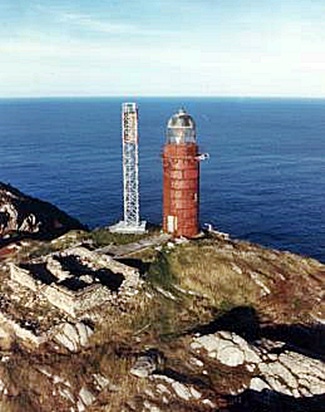
Baccalieu Island or Bacalhoo Island (/ˌbækəˈluː/) is a 5 km2 uninhabited island at the northern extremities of Conception Bay in Subdivision 1G, near the community of Red Head Cove, Newfoundland and Labrador, Canada. It is separated from the island of Newfoundland by Baccalieu Tickle, a small strait and an abundant fishing ground. The island has some trees but is mostly rocky.

AttributesValues
rdf:type
rdfs:label
  • Baccalieu Island (en)
  • Insulo Baccalieu (eo)
  • Île Baccalieu (fr)
  • Isola Baccalieu (it)
  • Ilha Baccalieu (pt)
  • Baccalieu Island (sv)
rdfs:comment
  • L’île Baccalieu est une petite île inhabitée à l'extrémité nord de la baie Conception, dans la province de Terre-Neuve-et-Labrador (Canada). Le nom baccalieu vient du portugais baccalhau (morue) ; les explorateurs portugais sont les premiers à avoir découvert l'île. En 1859, elle était encore appelée Île Bacalhao. On y a bâti vers 1850, un phare de 115 mètres de haut. (fr)
  • L'isola Baccalieu è una piccola isola disabitata situata nell'estremità settentrionale di Conception Bay, vicino alla comunità di Red Head Cove, in Canada. È separata dall'isola di Terranova da un piccolo stretto, il Baccalieu Tickle. Il nome Baccalieu deriva sia dal portoghese bacalhau, che dallo spagnolo bacalao, che dal basco baccalos, tutte espressioni il cui significato è "baccalà". È conosciuta dagli Europei almeno dal 1556, quando fu segnata su una mappa di Giacomo Gastaldi con il nome di Bacalaos.. (it)
  • A ilha Baccalieu é uma pequena ilha inabitada na extremidade norte da baia Conception, na província de Terra Nova e Labrador (Canadá). O nome baccalieu vem provavelmente do português baccalhau; os exploradores portugueses foram os primeiros a descobrir a ilha. (pt)
  • Baccalieu Island är en ö i Kanada. Den ligger i provinsen Newfoundland och Labrador, i den östra delen av landet, 1 800 km öster om huvudstaden Ottawa. Arean är 5,5 kvadratkilometer. Terrängen på Baccalieu Island är platt. Öns högsta punkt är 136 meter över havet. Den sträcker sig 6,1 kilometer i nord-sydlig riktning, och 1,6 kilometer i öst-västlig riktning. (sv)
  • Baccalieu Island or Bacalhoo Island (/ˌbækəˈluː/) is a 5 km2 uninhabited island at the northern extremities of Conception Bay in Subdivision 1G, near the community of Red Head Cove, Newfoundland and Labrador, Canada. It is separated from the island of Newfoundland by Baccalieu Tickle, a small strait and an abundant fishing ground. The island has some trees but is mostly rocky. (en)
  • Insulo Baccalieu estas 5 km² neloĝata insulo ĉe la norda parto de ĉe la komunumo , Kanado. Ĝi estas separata el la insulo Novlando fare de Baccalieu Tickle, nome malgranda markolo kaj abunda fiŝkaptejo. (eo)
differentFrom
name
  • North Point (en)
  • Baccalieu Island (en)
  • Baccalieu Island Lighthouse (en)
geo:lat
geo:long
foaf:depiction
  • http://commons.wikimedia.org/wiki/Special:FilePath/Iceberg_offer_Baccalieu_Island.jpg
dcterms:subject
Wikipage page ID
Wikipage revision ID
Link from a Wikipage to another Wikipage
Link from a Wikipage to an external page
sameAs
Faceted Search & Find service v1.17_git139 as of Feb 29 2024


Alternative Linked Data Documents: ODE     Content Formats:   [cxml] [csv]     RDF   [text] [turtle] [ld+json] [rdf+json] [rdf+xml]     ODATA   [atom+xml] [odata+json]     Microdata   [microdata+json] [html]    About   
This material is Open Knowledge   W3C Semantic Web Technology [RDF Data] Valid XHTML + RDFa
OpenLink Virtuoso version 08.03.3330 as of Mar 19 2024, on Linux (x86_64-generic-linux-glibc212), Single-Server Edition (378 GB total memory, 56 GB memory in use)
Data on this page belongs to its respective rights holders.
Virtuoso Faceted Browser Copyright © 2009-2024 OpenLink Software