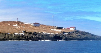
Green Island (in French: Île verte) is a rocky island near the mouth of Fortune Bay, Newfoundland. It is located about 10 km (6 mi) west of the Burin Peninsula of Newfoundland near Point May, and 10 km (6 mi) east of St. Pierre in the French overseas collectivity of Saint Pierre and Miquelon.
| Attributes | Values |
|---|
| rdf:type
| |
| rdfs:label
| - Île Verte (San Pedro y Miquelón) (es)
- Île Verte (Saint-Pierre eta Mikelune) (eu)
- Île Verte (océan Atlantique) (fr)
- Green Island (Fortune), Newfoundland and Labrador (en)
- Île Verte (Saint-Pierre e Miquelon) (it)
- Green Island, Newfoundland (Fortune Bay) (sv)
|
| rdfs:comment
| - Green Island (in French: Île verte) is a rocky island near the mouth of Fortune Bay, Newfoundland. It is located about 10 km (6 mi) west of the Burin Peninsula of Newfoundland near Point May, and 10 km (6 mi) east of St. Pierre in the French overseas collectivity of Saint Pierre and Miquelon. (en)
- Île Verte (ingelesez: Green Island; euskaraz: «uharte berdea») bokalean dagoen uharte harritsua da, Kanadako kanpoaldean. Labradorreko kostaldearen eta Saint-Pierre eta Mikelune uhartediaren artean dago, Langladetik 10 kilometrora. 1908an eraiki zuten lehen itsasargia, 1955ean ordezkatua izan zena, eta, ondoren, 1993an. Argiak hamar segundotik behin argitzen ditu kostaldeak, eta 16 itsas miliako distantziara ikusten da. Lainoa izanez gero, soinu seinaleak ere baditu egiturak. (eu)
- L'île Verte (en anglais Green Island) est une île de l'océan Atlantique, située à mi-parcours entre l'extrémité de la péninsule de Burin (Terre-Neuve) et l'archipel de Saint-Pierre-et-Miquelon. Son appartenance territoriale a longtemps été incertaine avant d’être résolue au 20e siècle. (fr)
- L'île Verte (Green Island in inglese) è un'isola situata tra l'arcipelago di Saint-Pierre e Miquelon (Francia) e la costa sud di Terranova (Canada). Questo isolotto scosceso e disabitato si trova al limite delle acque territoriali francesi e canadesi. La sua sovranità è oggi certa e tale territorio è interamente canadese. (it)
- Green Island är en ö i Kanada. Den ligger i provinsen Newfoundland och Labrador, i den östra delen av landet, 1 500 km öster om huvudstaden Ottawa. Arean är 0,36 kvadratkilometer. Ön ligger i viken Fortune Bay. Terrängen på Green Island är mycket platt. Öns högsta punkt är 33 meter över havet. Den sträcker sig 0,6 kilometer i nord-sydlig riktning, och 0,9 kilometer i öst-västlig riktning. (sv)
- Île Verte es una isla rocosa ubicada en la desembocadura de la bahía de Fortuna, en las afueras de la península de Burin, Terranova y Labrador, Canadá. Está situada entre la costa de Labrador y el archipiélago de San Pedro y Miquelón a 10 km de . En 1908 se construyó el primer faro, el cual fue sustituido en 1955 y posteriormente en 1993. La luz ilumina las costas cada diez segundos y es visible a una distancia de 16 millas náuticas. La estructura también dispone de señales sonoras en caso de niebla. (es)
|
| rdfs:seeAlso
| |
| geo:lat
| |
| geo:long
| |
| foaf:depiction
| |
| dcterms:subject
| |
| Wikipage page ID
| |
| Wikipage revision ID
| |
| Link from a Wikipage to another Wikipage
| |
| Link from a Wikipage to an external page
| |
| sameAs
| - Green Island (Fortune), Newfoundland and Labrador
- Green Island (Fortune), Newfoundland and Labrador
- Green Island (Fortune), Newfoundland and Labrador
- Green Island (Fortune), Newfoundland and Labrador
- Green Island (Fortune), Newfoundland and Labrador
- Green Island (Fortune), Newfoundland and Labrador
- Green Island (Fortune), Newfoundland and Labrador
- Green Island (Fortune), Newfoundland and Labrador
- Green Island (Fortune), Newfoundland and Labrador
- Green Island (Fortune), Newfoundland and Labrador
- Green Island (Fortune), Newfoundland and Labrador
|
| yearbuilt
| |
| yearlit
| |
| dbp:wikiPageUsesTemplate
| |
| thumbnail
| |
| caption
| - Location of Green Island between Newfoundland and Saint Pierre and Miquelon (en)
|
| construction
| - cast iron tower (en)
- skeletal tower (en)
|
| lat deg
| |
| lat min
| |
| lon deg
| |
| lon min
| |
| qid
| |
| shape
| - cylindrical tower with balcony and lantern (en)
- square frustum tower (en)
|
| lat dir
| |
| lat sec
| |
| lon dir
| |
| lon sec
| |
| georss:point
| |
| has abstract
| - Green Island (in French: Île verte) is a rocky island near the mouth of Fortune Bay, Newfoundland. It is located about 10 km (6 mi) west of the Burin Peninsula of Newfoundland near Point May, and 10 km (6 mi) east of St. Pierre in the French overseas collectivity of Saint Pierre and Miquelon. (en)
- Île Verte (ingelesez: Green Island; euskaraz: «uharte berdea») bokalean dagoen uharte harritsua da, Kanadako kanpoaldean. Labradorreko kostaldearen eta Saint-Pierre eta Mikelune uhartediaren artean dago, Langladetik 10 kilometrora. 1908an eraiki zuten lehen itsasargia, 1955ean ordezkatua izan zena, eta, ondoren, 1993an. Argiak hamar segundotik behin argitzen ditu kostaldeak, eta 16 itsas miliako distantziara ikusten da. Lainoa izanez gero, soinu seinaleak ere baditu egiturak. (eu)
|

![http://dbpedia.demo.openlinksw.com/describe/?url=http%3A%2F%2Fdbpedia.org%2Fresource%2FGreen_Island_%28Fortune%29%2C_Newfoundland_and_Labrador&invfp=IFP_OFF&sas=SAME_AS_OFF]()


![[RDF Data]](/fct/images/sw-rdf-blue.png)


![[RDF Data]](/fct/images/sw-rdf-blue.png)


![[cxml]](/fct/images/cxml_doc.png)
![[csv]](/fct/images/csv_doc.png)
![[text]](/fct/images/ntriples_doc.png)
![[turtle]](/fct/images/n3turtle_doc.png)
![[ld+json]](/fct/images/jsonld_doc.png)
![[rdf+json]](/fct/images/json_doc.png)
![[rdf+xml]](/fct/images/xml_doc.png)
![[atom+xml]](/fct/images/atom_doc.png)
![[html]](/fct/images/html_doc.png)