About: Observation Hill (McMurdo Station)     Goto   Sponge   NotDistinct   Permalink

An Entity of Type : yago:Tract108673395, within Data Space : dbpedia.demo.openlinksw.com associated with source document(s)
QRcode icon
http://dbpedia.demo.openlinksw.com/describe/?url=http%3A%2F%2Fdbpedia.org%2Fresource%2FObservation_Hill_%28McMurdo_Station%29&invfp=IFP_OFF&sas=SAME_AS_OFF

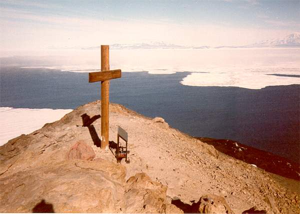
Observation Hill is a steep 754-foot (230 m) hill adjacent to McMurdo Station in Antarctica and commonly called "Ob Hill." It is frequently climbed to get good viewing points across the continent. Regular clear skies give excellent visibility. Observation Hill is a lava dome and one of many volcanoes comprising the Hut Point Peninsula.

AttributesValues
rdf:type
rdfs:label
  • Observation Hill (de)
  • Colina Observación de la Base McMurdo (es)
  • Observation Hill (fr)
  • Observation Hill (McMurdo Station) (en)
  • Observation Hill (pt)
  • Observation Hill (sv)
  • 觀測山 (麥克默多站) (zh)
rdfs:comment
  • Der Observation Hill (englisch für Beobachtungshügel) ist ein 230 m hoher und kegelförmiger Hügel am südwestlichen Ende der Hut-Point-Halbinsel im Südwesten der antarktischen Ross-Insel. Er überragt das Kap Armitage. Entdeckt und benannt wurde er von Teilnehmern der Discovery-Expedition (1901–1904) unter der Leitung des britischen Polarforschers Robert Falcon Scott. Namensgebend ist der Umstand, dass sich vom Gipfel des Hügels eine besonders gute Aussicht über das umliegende Gebiet bietet. (de)
  • La colina Observación, en inglés Observation Hill es una colina empinada de 754 pies —230 m— adyacente a la Base McMurdo en la Antártida y comúnmente llamada Ob Hill. Con frecuencia se sube para obtener buenos puntos de observación hacia el continente. Cuando el cielo está despejado da una excelente visibilidad. Ob Hill es una cúpula de lava y uno de los muchos volcanes que están situados en la península de Hut Point de la isla de Ross.​ (es)
  • Observation Hill, communément appelée Ob Hill, prononcé /ɒb hɪl/, est une colline de l'île de Ross en Antarctique et surplombant la base antarctique McMurdo. (fr)
  • Observation Hill is a steep 754-foot (230 m) hill adjacent to McMurdo Station in Antarctica and commonly called "Ob Hill." It is frequently climbed to get good viewing points across the continent. Regular clear skies give excellent visibility. Observation Hill is a lava dome and one of many volcanoes comprising the Hut Point Peninsula. (en)
  • Observation Hill är en kulle i Antarktis. Den ligger i Östantarktis. Nya Zeeland gör anspråk på området. Toppen på Observation Hill är 230 meter över havet. Terrängen runt Observation Hill är platt åt sydväst, men åt nordost är den kuperad. Havet är nära Observation Hill åt sydväst. Den högsta punkten i närheten är Crater Hill, 335 meter över havet, 2,2 km nordost om Observation Hill. Trakten är glest befolkad. Närmaste befolkade plats är McMurdo Station, 0,49 km norr om Observation Hill. (sv)
  • 觀測山是南極洲的山峰,位於羅斯島,毗鄰麥克默多站,海拔高度230米,山上設有9英尺的十字架紀念羅伯特·斯科特探險隊逝世的隊員,現時由南極條約體系管理。 (zh)
  • Observation Hill (Colina de Observação) é uma grande colina (cerca de 230 metros de altura) adjacente à Estação McMurdo, na Antártida. É também conhecida como Ob Hill. Escala-se frequentemente a colina para poder conseguir boa visão da região da estação, já que, quando o tempo está bom, obtém-se um excelente campo de visão. (pt)
geo:lat
geo:long
foaf:depiction
  • http://commons.wikimedia.org/wiki/Special:FilePath/Cross_on_Observation_Hill,_McMurdo_Station.jpg
  • http://commons.wikimedia.org/wiki/Special:FilePath/Observation_Hill.jpg
  • http://commons.wikimedia.org/wiki/Special:FilePath/Summit_ob_hill.jpg
dcterms:subject
Wikipage page ID
Wikipage revision ID
Link from a Wikipage to another Wikipage
Link from a Wikipage to an external page
  • http://www.southpolestation.com/obhill/cross1.jpg
sameAs
dbp:wikiPageUsesTemplate
thumbnail
georss:point
  • -77.85 166.69
has abstract
  • Der Observation Hill (englisch für Beobachtungshügel) ist ein 230 m hoher und kegelförmiger Hügel am südwestlichen Ende der Hut-Point-Halbinsel im Südwesten der antarktischen Ross-Insel. Er überragt das Kap Armitage. Entdeckt und benannt wurde er von Teilnehmern der Discovery-Expedition (1901–1904) unter der Leitung des britischen Polarforschers Robert Falcon Scott. Namensgebend ist der Umstand, dass sich vom Gipfel des Hügels eine besonders gute Aussicht über das umliegende Gebiet bietet. (de)
Faceted Search & Find service v1.17_git139 as of Feb 29 2024


Alternative Linked Data Documents: ODE     Content Formats:   [cxml] [csv]     RDF   [text] [turtle] [ld+json] [rdf+json] [rdf+xml]     ODATA   [atom+xml] [odata+json]     Microdata   [microdata+json] [html]    About   
This material is Open Knowledge   W3C Semantic Web Technology [RDF Data] Valid XHTML + RDFa
OpenLink Virtuoso version 08.03.3330 as of Mar 19 2024, on Linux (x86_64-generic-linux-glibc212), Single-Server Edition (378 GB total memory, 60 GB memory in use)
Data on this page belongs to its respective rights holders.
Virtuoso Faceted Browser Copyright © 2009-2024 OpenLink Software