| rdfs:comment
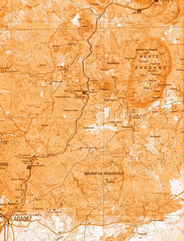
| - جبل إيدوكال ن تاغيس (بالأمازيغية : ⵉⴷⴷⵓⴽⴰⵍ ⵏ ⵜⴰⵖⵉⵙ) هو جبل في النيجر يعتبر أعلى نقطة في البلاد وفي سلسة جبال آير. ارتفاعه 2022 مترا.يقع في جنوب جبال آير ، في ، على حدود مقاطعتي أرليت و تشيروزرين . (ar)
- Mont Idoukal-n-Taghès (též Mont Bagzane či Mont Bagzan, 2022 m n. m.) je hora v pohoří Aïr v západní Africe. Leží ve středním Nigeru v regionu na hranicích departementů a . Jedná se o nejvyšší horu Nigeru. (cs)
- Der Idoukal-n-Taghès ist mit einer Höhe von 2022 m der höchste Berg Nigers. Er gehört zu den Monts Bagzane, einem Massiv im Süden des Hochgebirges Aïr, und wird deshalb auch als Mont Bagzane bezeichnet. Der halbmondförmige Berg ist vulkanischen Ursprungs. (de)
- Mont Idoukal-n-Taghès edo Mont-Bagzane Nigerko mendirik altuena da, Aïr mendigunearen hego-erdialdean kokatuta dagoena. Agadez hiririk gertuena dugu. (eu)
- Le mont Indoukat-n-Taglès (variantes orthographiques : Indoukal, Taghès) est une montagne du Niger, point culminant du pays et du massif de l'Aïr. Son altitude est de 2 022 mètres. Il est situé dans le sud de l'Aïr, dans les monts Bagzane, à la limite des départements d'Arlit et de Tchirozérine. (fr)
- Il Mont Idoukal-n-Taghès è una montagna dell'Africa occidentale, situata in Niger. Viene chiamato anche Mont Bagzane o Mont Bagzan. (it)
- Mont Idoukal-n-Taghès, ook bekend als Mont Bagzane, is een berg in Tabelot, Niger. De Mont Idoukal-n-Taghès is onderdeel van het bergmassief Aïr. De berg geldt als hoogste punt van Niger. (nl)
- Mont Idoukal-n-Taghès lub Baguezane – szczyt w pasmie Aïr, w Afryce Zachodniej. Leży w środkowym Nigrze i jest najwyższym szczytem tego kraju oraz pasma Aïr. (pl)
- El Mont Idoukal-n-Taghès, també anomenat Mont Bagzane i Mont Bagzan, és la muntanya més alta del Níger amb una altitud de 2.022 msnm. Es troba a la zona sud de les muntanyes Aïr, a l'extrem nord de l’altiplà de Bagzane. La localitat i centre de peregrinació d' es troba als seus peus. Degut a la seva altitud aquesta muntanya acull diverses espècies vegetals tropicals i saharianes-mediterrànies no registrades en cap altra indret del país. Per honorar el punt més alt del Níger, l'avió oficial del es diu Mont Bagzane. (ca)
- Mont Idoukal-n-Taghès (also Mont Bagzane, Mont Bagzan) is the highest mountain in Niger. Mont Idoukal-n-Taghès is located in the south central Aïr Mountains, and is at the northern end of the . The village and pilgrimage site of sits at the base of the peak. The Aouderas valley, the path of a seasonal wash (or Kouri) runs south from the foot of Idoukal-n-Taghès towards Agadez, the regional capital. The oasis town of Aouderas is just southwest of the mountain. Due to its high elevation, mount Idoukal'n'Taghes has been found to host a number of Saharan-Mediterranean and Tropical plant species that have never been recorded elsewhere in Niger. (en)
- El monte Idoukal-n-Taghès, también conocido como Monte Bagzane o Bagzan, es la montaña más elevada de Níger, con una altitud de 2022 msnm. Se encuentra en la parte central-meridional del Macizo de Air, en el extremo norte de la . La localidad de Aoueras se encuentra al suroeste de la montaña mientras que el centro de peregrinación de Abatol se encuentra a sus pies. Debido a su elevada altitud, el monte Idoukal-n-Taghès alberga varias especies vegetales tropicale y sahariano-mediterráneas no registradas en ninguna otra parte del país. (es)
- O monte Idoukal-n-Taghès, também chamado Bagzane ou Bagzan é a mais alta montanha do Níger, na zona centro-sul das Montanhas Aïr, e na parte norte do . O centro de peregrinações de fica no seu sopé. Devido à elevada altitude, o monte Idoukal'n'Taghès é habitat de uma série de espécies saarianas-mediterrânicas e tropicais que no Níger apenas se encontram nas suas encostas. O avião oficial do presidente do Níger chama-se Mont Bagzane. (pt)
- Идукальн-Тагес — самая высокая гора в Нигере высотой 2022 м. Расположена в северной части горного массива Багзане на юге высокогорья Аира. Гора в форме полумесяца имеет вулканическое происхождение. Идукальн-Тагес расположен на северо-западе муниципалитета в департаменте Чирозерин. В долине к северу от горы расположен оазис Тимиа. Ближайший крупный город — Агадес, около 127 км по прямой. В 2001 году была проложена трасса, подходящая для внедорожных мотоциклов, которая ведёт с запада к Багзане. Обычно в качестве вьючных животных используются ослы. Для верблюдов горные тропы слишком скалистые и крутые. (ru)
|

![http://dbpedia.demo.openlinksw.com/c/5qL9x4961b]()


![[RDF Data]](/fct/images/sw-rdf-blue.png)


![[RDF Data]](/fct/images/sw-rdf-blue.png)


![[cxml]](/fct/images/cxml_doc.png)
![[csv]](/fct/images/csv_doc.png)
![[text]](/fct/images/ntriples_doc.png)
![[turtle]](/fct/images/n3turtle_doc.png)
![[ld+json]](/fct/images/jsonld_doc.png)
![[rdf+json]](/fct/images/json_doc.png)
![[rdf+xml]](/fct/images/xml_doc.png)
![[atom+xml]](/fct/images/atom_doc.png)
![[html]](/fct/images/html_doc.png)